Garrotxa Cultour - Página Principal

Menu Home
Garrotxa Cultour Proposals
The Lava Flows

CL
The Lava Flows

  1. A+
  2. A-
4 Elements of the PROPOSALS IN THIS TOWN

Description

Change to child text Change to normal description
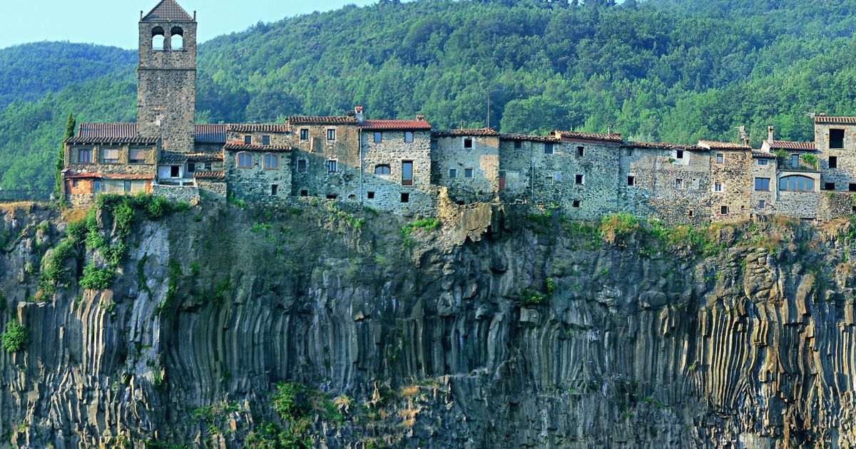
In this route we will wander around several spots of La Garrotxa, where there was a rich and diverse volcanic life millions of years ago. Some eruptions produced such a great amount of lava that it spread across the valleys and eventually cooled down in the shape of basalt, forming what we these days call “lava flows”. We will be able to see, at first hand, the different lava flows and the consequences that river erosion has had. These are constantly trying to draw its original course back and keep cutting lava flows with the help of environmental elements. The combination of volcanic stone, water that filters through it, rivers, cold and heat and millions of years have sculpted some spectacular scarps and some of the most singular geological areas. We will start our route in Castellfollit de la Roca, on the bridge over the river Toronell, admiring the Gothic remains, which are still preserved in the base of the present metallic bridge. The bridge lasted many centuries until a flood took it in 1970. Over the other river of the village, the river Fluvià, we will find the broken bridge, just a few metres away from the present one. This bridge takes us back in history, since getting over the river Fluvià and going up to the village at this point has been a strategic step to connect the comarcaof Empordà and Olot. The constructions and destructions of the bridge have testified the different ages of our recent history and the difficulties it has entailed. The two bridges were used for crossing the rivers found beneath the village, on each side of the rivers Toronell and Fluvià. These rivers precisely explain the geological importance of Castellfollit. The village is located at the top of a scarp composed of two different lava flows: one coming from Batet, 217,000 years old, which arrived there following the Fluvià valley, and a second one coming from Begudà, 192,000 years old, following the course of the river Toronell. As millenniums went by, blocks of scarp (due towater leakage) and the erosive action of the rivers ended up cutting the cooled lava turned into basalt until leaving it as we know it today.

From Castellfollit we can take the Castellfollit-Begudà-Sant Joan les Fonts route, perfectly signposted. It can be made in less than four hours on food, but it is also possible to go by car along the road that links both villages. In Sant Joan les Fonts there are different tracks around the village surroundings. On the one hand, we will be able to walk along the Fonts and Verlets route, in which the water becomes a key element. It is a track with several combinations, with part of the itinerary being accessible, along which we will pass by channels and creeks. We will also visit springs such as Can Xerbanda, Fontfreda, Mulleres, Font Bona or Rompuda. Bear in mind that, wandering around the village, you will surely come across other springs, such as Cal Rei or Can Brunsó, built for public use at the beginning of the 20th century. In the Les Tres Colades and Boscarró routes the key elements will be, again, geology and volcanism. The route starts next to the parish church, going up the stairs on the right and following the signposted itinerary. We will go down to the bank of the river Fluvià, in front of Molí Fondo, where three superimposed lava flows meet, each belonging to a different period. Further up, in the area of Boscarró, we will be able to see the shapes produced by the third and last lava flow when cooling down, such as prisms and basaltic stone masses. In this spot we will also pass by an old quarry which used volcanic stone, highly valued in the construction of buildings or streets for its characteristics, for being a resistant and insulating material. Leaving Boscarró behind, the route continues along the side of the creek of Bianya, until arriving to Fontfreda scarps, where, again, we will appreciate the different geometrical shapes from the third lava flow. Although the route is not difficult, in this stretch proper footwear is important, so as to avoid slipping. We will also have to walk on chipped basaltic stones and cross the creek a couple of times. In this route we can admire how, as millenniums have gone by, several layers of material coming from the inside of the Earth have been superimpo sing themselves. Volcanoes expelled lava, which went down the territory covering everything until cooling down.

But basaltic cliffs can also be found elsewhere, since lava flows spread throughout the valleys of the volcanic region of Olot. One of the places where you can see it more clearly is in the middle of Santa Pau, where the erosive action of the Ser River has revealed a very interesting basaltic cliff, but it can also be found in Olot, next to the river Fluvià, between the neighborhood of Les Tries and La Canya.

The following erosion of the rivers has left the land as we see it today.
This route will be useful to learn how, many years ago, La Garrotxa was not as quiet as it is now, because volcanoes were belching outlava from inside the Earth. We can check this in Castellfollit de la Roca, where, near the river Fluvià, we will see a very high wall. This wall is not made by a person or a machine, it is made by nature. Thousands of years ago, the volcanoes in La Garrotxa belched out so much lava that it got here and reached this height. Lava is a very hot liquid made of dark stone, which volcanoes belch out when they are active. It comes from the inside of the Earth, far below our feet. When it cools down it turns into hard stone again. As centuries went by, rivers progressively melted the lava stones forming this huge wall we have opposite us. Many years later, people built houses and streets on it, resulting into what nowadays is the village of Castellfollit de la Roca. Near Sant Joan de les Fonts we can also fins similar walls, but smaller and with lava from different lava flows and geometrical shapes. Luckily, this was a long time ago. It is highly possible that the eruption of the last volcanoes in La Garrotxa happened at the same time that the first people who inhabited this area were living there. Can you imagine it? They always had to be watching out and be ready to run to the top of the mountains if lava started belching out, because it is a very hot liquid and nothing can stop it. These days, volcanoes are asleep, but they could wake up at any time. We will need to keep our eyes open! Apart from this, in this route we will also find out many other things. In Castellfollit de la Roca, in front of the bridge remains over the river Toronell, where you can now see the metallic bridge, during many years there was a stone bridge big and safe. As the river Toronell takes the rain that falls on the mountains and, in the past it used to rain a lot, there were sometimes floods. One of these floods took place less than 50 years ago and it took that bridge, which was over a hundred years old. That is why we can only see the stones that water did not manage sweep along. In Sant Joan les Fonts we can find out the reason for the name of the village. The Fonts i Verlets route is an excursion where we will go by fields, creeks and humid areas, especially springs, such as Fontfreda, Mulleres, Font Bona, among others. If we are thirsty, we only have to open our mouths, water is cool and free!
These stone walls have been seen mainly on the river Fluvià, when it passes through Sant Joan les Fonts and Castellfollit de la Roca. But this same river also passes through Olot and there it also lets in view more stone walls, but they are not so high.

Another river that also leaves in view another stone wall is the Ser, just when it passes through Santa Pau.

Additional data

Recommendation: To try the different combinations which the route from Fonts i Verlets to Sant Joan les Fonts has to offer. The route has several crossings which allow us to follow different itineraries, most of them signposted and with the time that takes walking from one point to the other indicated. From this route we can also move on onto the three lava flows one and Boscarró as well.

More information

Geography: The area of Castellfollit de la Roca and Sant Joan les Fonts lava flows is located in the center of the Comarca of La Garrotxa, near Olot. Both are in the river Fluvià valley, which comes from Plana d’en Bas, goes through the city of Olot, turns to the east and goes down to La Canya, Joan les Fonts and Castellfollit de la Roca. Beneath the vertex of Castellfollit de la Roca scarps, the river Turonell meets Fluvià, which follows its course across the plains in the
Comarca of Empordà until flowing into Sant Pere Pescador. This valley has been a common crossing point to connect La Garrotxa with Alt Empordà and Roses harbour. A great part of the territory in Olot, as the city it self or the villages of Santa Pau, Sant Joan les Fonts and Castellfollit de la Roca and the valleys which connect them, are located on basaltic lava flows.

The Lava Flows: Lava flows are the product of volcanic eruptions that belch out fluid lava. This magma can travel long distances covering everything it comes across. When it cools down, it turns into different geological constructions. The cooling is another process which marks the geology of the element. The basaltic colonnade found in Castellfollit was produced by the superposition of two lava flows. The first one, 217,000 years ago, came from Batet, from where it went down over Fluvià valley. 192,000 years ago, another flow went down, in this case it came from the other side, Turonell valley, and it covered the former one. At first sight we can see the first one has the shape of a column and the part below is made of slabs. Between the two lava flows we will be able to see the sediments left in the middle. During many years they formed the ground, but then they were covered by a second flow. We will also see this in Sant Joan les Fonts, in the Molí Fondo area. Castellfollit de la Roca scarps are nowadays a kilometer long and their highest point gets to a height of 50 meters. The scarp has suffered a setback due to the erosion produced by two rivers and the process of congelifraction. This is produced when rainwater filters through volcanic stone. On one hand, it changes its chemical composition and, on the other, when water cools downs it gains volume and helps to split the stone. This is why the process of the scarps is a phenomenon that never stops. Geologically speaking, Sant Joan les Fonts is not as spectacular as Castellfollit, although we can also find a singular geological richness there. In the case of Molí Fondo, we will see three superimposed lava flows. The first one, coming from Batet volcanoes, settled and cooled down 600,000 years ago. On top of it, the second lava flow was settled, 150,000 years ago, and on top of it, the third one, 120,000 years ago, coming from Garrinada volcano. This last flow, the most recent one, is the one we can see in Boscarró, Prismes and Lloses, which show us how the cooling process of the lava took various shapes depending on how it was produced. When lava cooled down being still, it took take the shape of a column, while if the liquid was moving, it took the shape of stone blocks. Lava flows can take even a third shape, the massive shape, made of big stone blocks. In this third lava flow, we will admire the three shapes. Following the path next to Bianya creek, we will get to Fontfreda scarps. Along the tour we will be able to see how the Bianya creek and the process of congelifraction have eroded the land during millenniums. It must be noted that in Boscarró area, over the little plain located on top of it, some remains of a Iberian village have been found, although there is still a lot to find out.