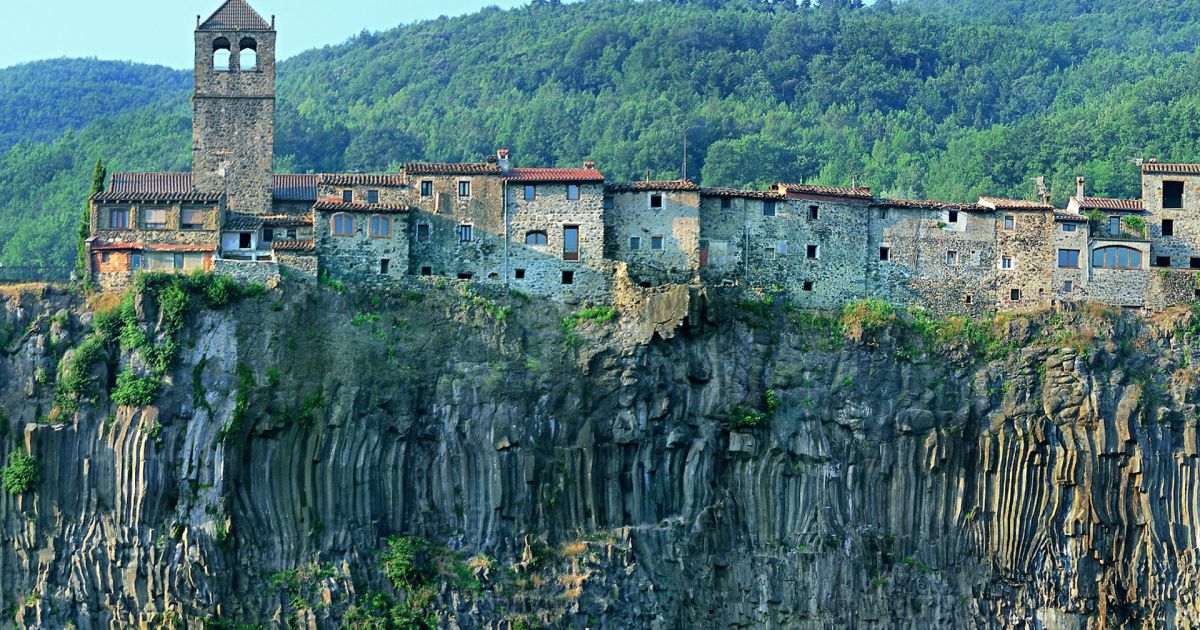
In this route we will wander around several spots of La Garrotxa, where there was a rich and diverse volcanic life millions of years ago. Some eruptions produced such a great amount of lava that it spread across the valleys and eventually cooled down in the shape of basalt, forming what we these days call “lava flows”. We will be able to see, at first hand, the different lava flows and the consequences that river erosion has had. These are constantly trying to draw its original course back and keep cutting lava flows with the help of environmental elements. The combination of volcanic stone, water that filters through it, rivers, cold and heat and millions of years have sculpted some spectacular scarps and some of the most singular geological areas. We will start our route in Castellfollit de la Roca, on the bridge over the river Toronell, admiring the Gothic remains, which are still preserved in the base of the present metallic bridge. The bridge lasted many centuries until a flood took it in 1970. Over the other river of the village, the river Fluvià, we will find the broken bridge, just a few metres away from the present one. This bridge takes us back in history, since getting over the river Fluvià and going up to the village at this point has been a strategic step to connect the comarcaof Empordà and Olot. The constructions and destructions of the bridge have testified the different ages of our recent history and the difficulties it has entailed. The two bridges were used for crossing the rivers found beneath the village, on each side of the rivers Toronell and Fluvià. These rivers precisely explain the geological importance of Castellfollit. The village is located at the top of a scarp composed of two different lava flows: one coming from Batet, 217,000 years old, which arrived there following the Fluvià valley, and a second one coming from Begudà, 192,000 years old, following the course of the river Toronell. As millenniums went by, blocks of scarp (due towater leakage) and the erosive action of the rivers ended up cutting the cooled lava turned into basalt until leaving it as we know it today.
From Castellfollit we can take the Castellfollit-Begudà-Sant Joan les Fonts route, perfectly signposted. It can be made in less than four hours on food, but it is also possible to go by car along the road that links both villages. In Sant Joan les Fonts there are different tracks around the village surroundings. On the one hand, we will be able to walk along the Fonts and Verlets route, in which the water becomes a key element. It is a track with several combinations, with part of the itinerary being accessible, along which we will pass by channels and creeks. We will also visit springs such as Can Xerbanda, Fontfreda, Mulleres, Font Bona or Rompuda. Bear in mind that, wandering around the village, you will surely come across other springs, such as Cal Rei or Can Brunsó, built for public use at the beginning of the 20th century. In the Les Tres Colades and Boscarró routes the key elements will be, again, geology and volcanism. The route starts next to the parish church, going up the stairs on the right and following the signposted itinerary. We will go down to the bank of the river Fluvià, in front of Molí Fondo, where three superimposed lava flows meet, each belonging to a different period. Further up, in the area of Boscarró, we will be able to see the shapes produced by the third and last lava flow when cooling down, such as prisms and basaltic stone masses. In this spot we will also pass by an old quarry which used volcanic stone, highly valued in the construction of buildings or streets for its characteristics, for being a resistant and insulating material. Leaving Boscarró behind, the route continues along the side of the creek of Bianya, until arriving to Fontfreda scarps, where, again, we will appreciate the different geometrical shapes from the third lava flow. Although the route is not difficult, in this stretch proper footwear is important, so as to avoid slipping. We will also have to walk on chipped basaltic stones and cross the creek a couple of times. In this route we can admire how, as millenniums have gone by, several layers of material coming from the inside of the Earth have been superimpo sing themselves. Volcanoes expelled lava, which went down the territory covering everything until cooling down.
But basaltic cliffs can also be found elsewhere, since lava flows spread throughout the valleys of the volcanic region of Olot. One of the places where you can see it more clearly is in the middle of Santa Pau, where the erosive action of the Ser River has revealed a very interesting basaltic cliff, but it can also be found in Olot, next to the river Fluvià, between the neighborhood of Les Tries and La Canya.
The following erosion of the rivers has left the land as we see it today.
